Print this worksheet, or choose "Save as PDF" in the print window to share a file.
Chart worksheet
Charts to read and discuss
Name:
Class:
Date:
Chart 1 of 3 · Wealth
How is U.S. household wealth divided?
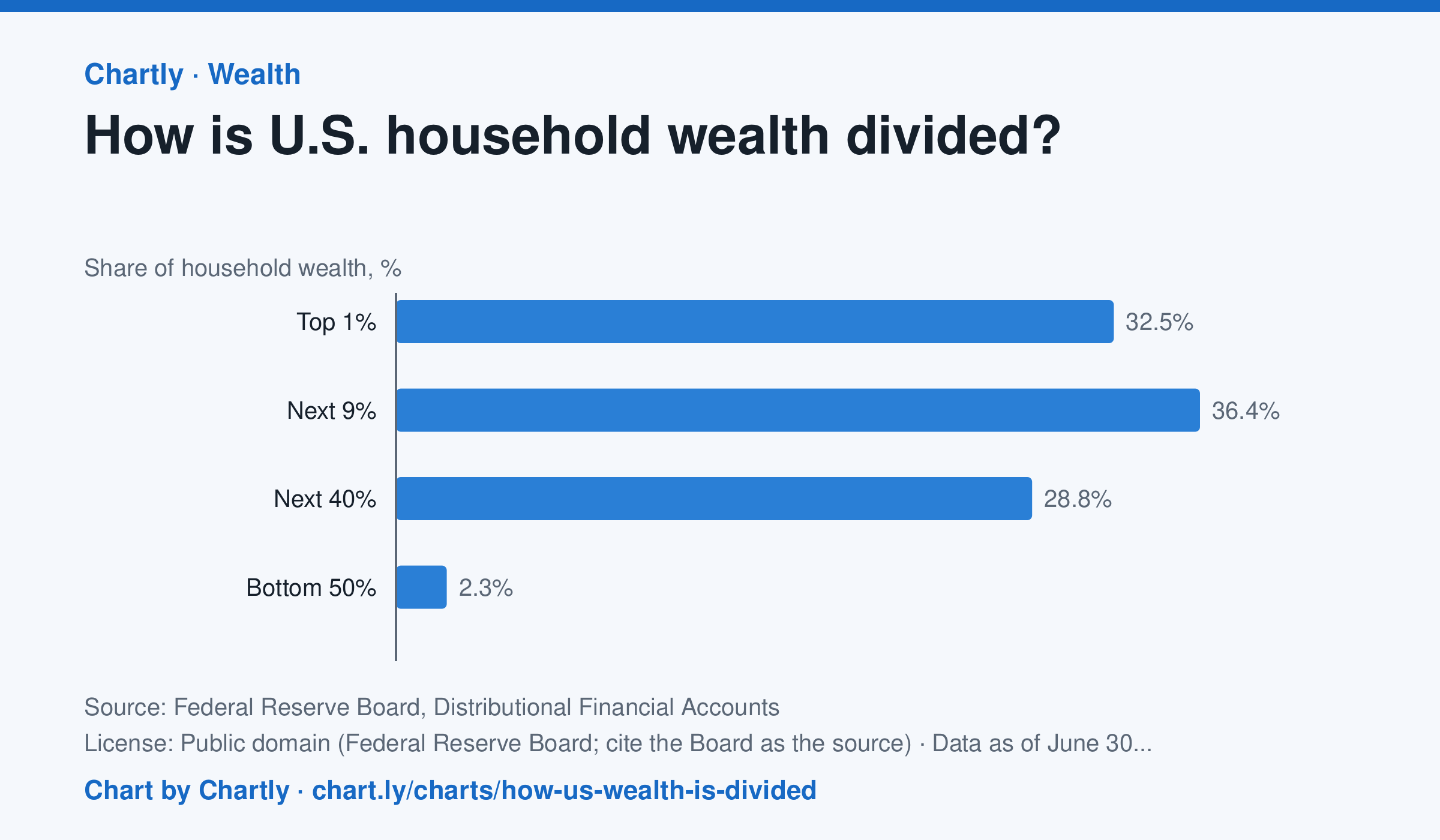
At the end of June 2026, the wealthiest 1% of U.S. households held 32.5% of all household wealth, the next 9% held 36.4%, the next 40% held 28.8% and the bottom 50% held 2.3%. In 1989 the shares were 22.8%, 38.0%, 35.7% and 3.5%. Wealth here is net worth: what households own (homes, stocks and mutual funds, pensions and retirement accounts, private businesses, cars and other belongings, bank deposits) minus what they owe (mortgages, credit cards, student and car loans). The Fed estimates each quarter by combining its Financial Accounts with its Survey of Consumer Finances, taken every three years, so the newest quarters are estimates that get revised.
Source: Federal Reserve Board, Distributional Financial Accounts (Public domain (Federal Reserve Board; cite the Board as the source)) · Data as of Jun 30, 2026
How to read this chart
Each bar is one group of U.S. households' share of all household wealth, so the four bars add up to 100%. The groups are different sizes: the top 1% is one household in every hundred, while the bottom 50% is half of all households. Compare each group's share of wealth with its share of households.
Questions
- Which group holds the largest share of wealth? Is it the group with the most households?
- If wealth were split evenly, what share would the bottom 50% hold? How far is the chart from that?
- The takeaway gives the 1989 shares too. Which groups gained a share since then, and which lost one?
Chart and numbers: chart.ly/charts/how-us-wealth-is-divided · More free charts at chart.ly
Chart 2 of 3 · Inflation
How much does a dozen eggs cost in the US?
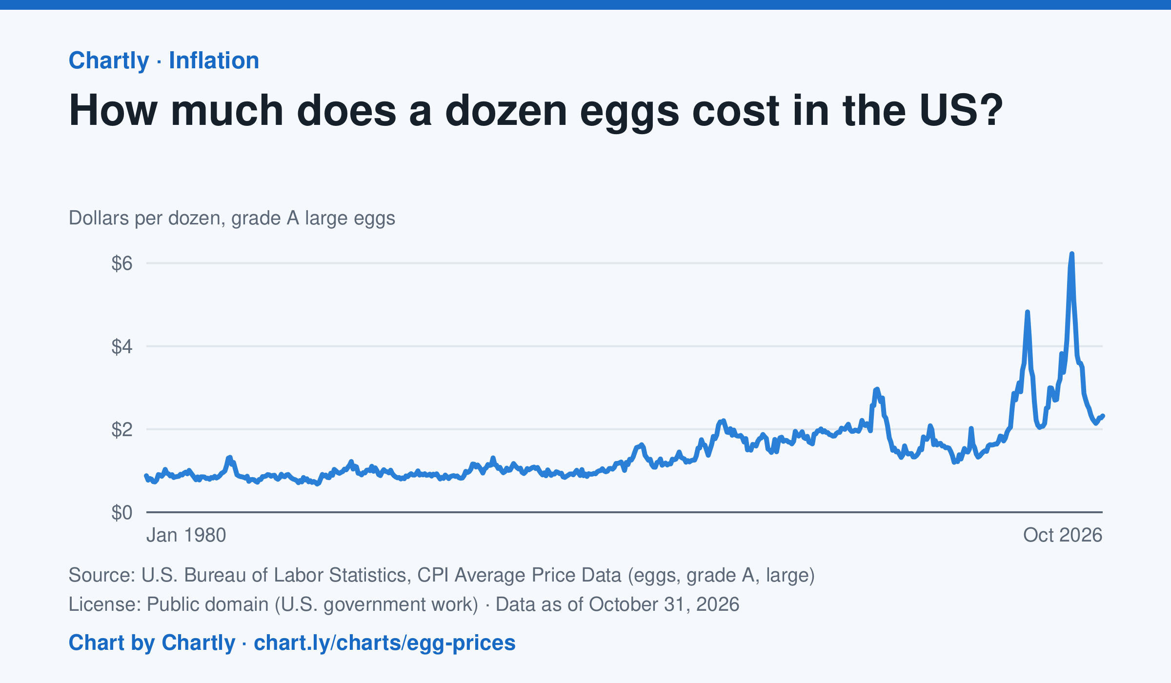
A dozen grade A large eggs averaged $2.32 in October 2026. The record so far is $6.23 in March 2025; prices spiked in 2023 and 2025 when bird flu cut the number of laying hens. Prices are BLS averages across US cities since 1980, when this series begins, in dollars of the day, not adjusted for inflation. October 2025 is missing because a lapse in federal funding stopped data collection.
Source: U.S. Bureau of Labor Statistics, CPI Average Price Data (eggs, grade A, large) (Public domain (U.S. government work)) · Data as of Oct 31, 2026
How to read this chart
Each point is the average price of a dozen grade A large eggs in U.S. cities in one month, in dollars. The axis starts at zero, so the height of the line shows the true price. Spikes often come when bird flu forces farms to lose laying hens, which cuts the supply of eggs.
Questions
- What was the highest price on the chart, and how many times more is it than the lowest?
- Showing your work, by what percent did the price change from the first month on the chart to the newest?
- When fewer hens are laying eggs but people want just as many, what happens to the price, and why?
Chart and numbers: chart.ly/charts/egg-prices · More free charts at chart.ly
Chart 3 of 3 · Climate
Which US states have warmed the most?
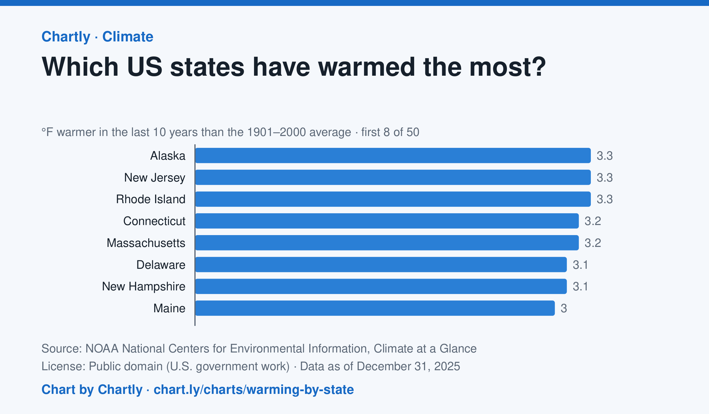
In the 10 years through 2025, Alaska was among the states that warmed most, averaging 3.3°F warmer than in 1901–2000, while Oklahoma was among those that warmed least, 1.6°F; the contiguous US warmed 2.2°F. Alaska's records start in 1925, so its baseline is 1925–2000. Hawaii's start in 1991, so it isn't included.
Source: NOAA National Centers for Environmental Information, Climate at a Glance (Public domain (U.S. government work)) · Data as of Dec 31, 2025
How to read this chart
Each bar shows how much warmer a state's last 10 years were than its average for 1901 to 2000, in degrees Fahrenheit. Ten years are averaged so one hot or cold year doesn't decide a state's place. The dashed line is the whole lower 48 states.
Questions
- Which states warmed the most and the least? How many degrees apart are they?
- Do the states that warmed most sit together in one part of the country, or are they spread out?
- Why do scientists compare with a long average like 1901 to 2000 instead of with just last year?
Chart and numbers: chart.ly/charts/warming-by-state · More free charts at chart.ly