Print this worksheet, or choose "Save as PDF" in the print window to share a file.
Chart worksheet
Charts to read and discuss
Name:
Class:
Date:
Chart 1 of 2 · Crime
Which big U.S. cities have the most burglaries?
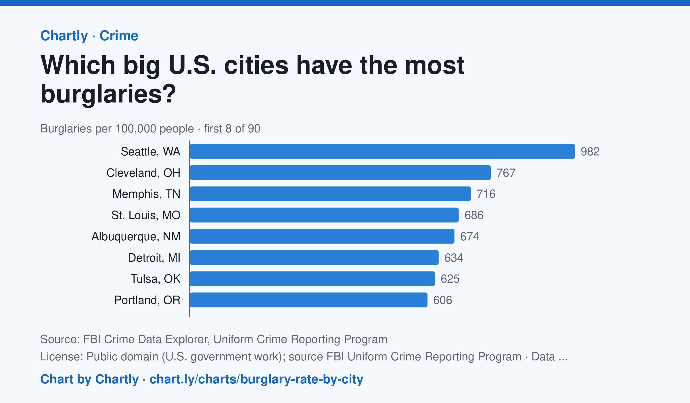
In 2025, Seattle, WA had the highest burglary rate of the 89 biggest U.S. cities whose police reported a full year to the FBI, about 982 per 100,000 people, followed by Cleveland, OH (767) and Memphis, TN (716). Virginia Beach, VA (62) and Gilbert, AZ (64) had the lowest; the U.S. rate was about 195. A burglary is breaking into a home, business or other building to steal or commit another crime. Departments that didn't report a full year are left out (for 2025, New Orleans, Orlando and St. Petersburg, Florida). Rates count only crimes reported to police. Each rate is per person the department serves, and a few, such as Las Vegas, Honolulu, Jacksonville and Louisville, serve their whole county. A city's rate also depends on where its borders fall, so compare cities with care.
Source: FBI Crime Data Explorer, Uniform Crime Reporting Program (Public domain (U.S. government work); source FBI Uniform Crime Reporting Program) · Data as of Dec 31, 2025
Questions
- In one sentence of your own, what does this chart show?
- Find the biggest change or difference in the chart. What might explain it?
- Who collected these numbers, and how recent are they? What else would you want to know before drawing a conclusion?
Chart and numbers: chart.ly/charts/burglary-rate-by-city · More free charts at chart.ly
Chart 2 of 2 · Road safety
Are U.S. roads getting safer per mile driven?
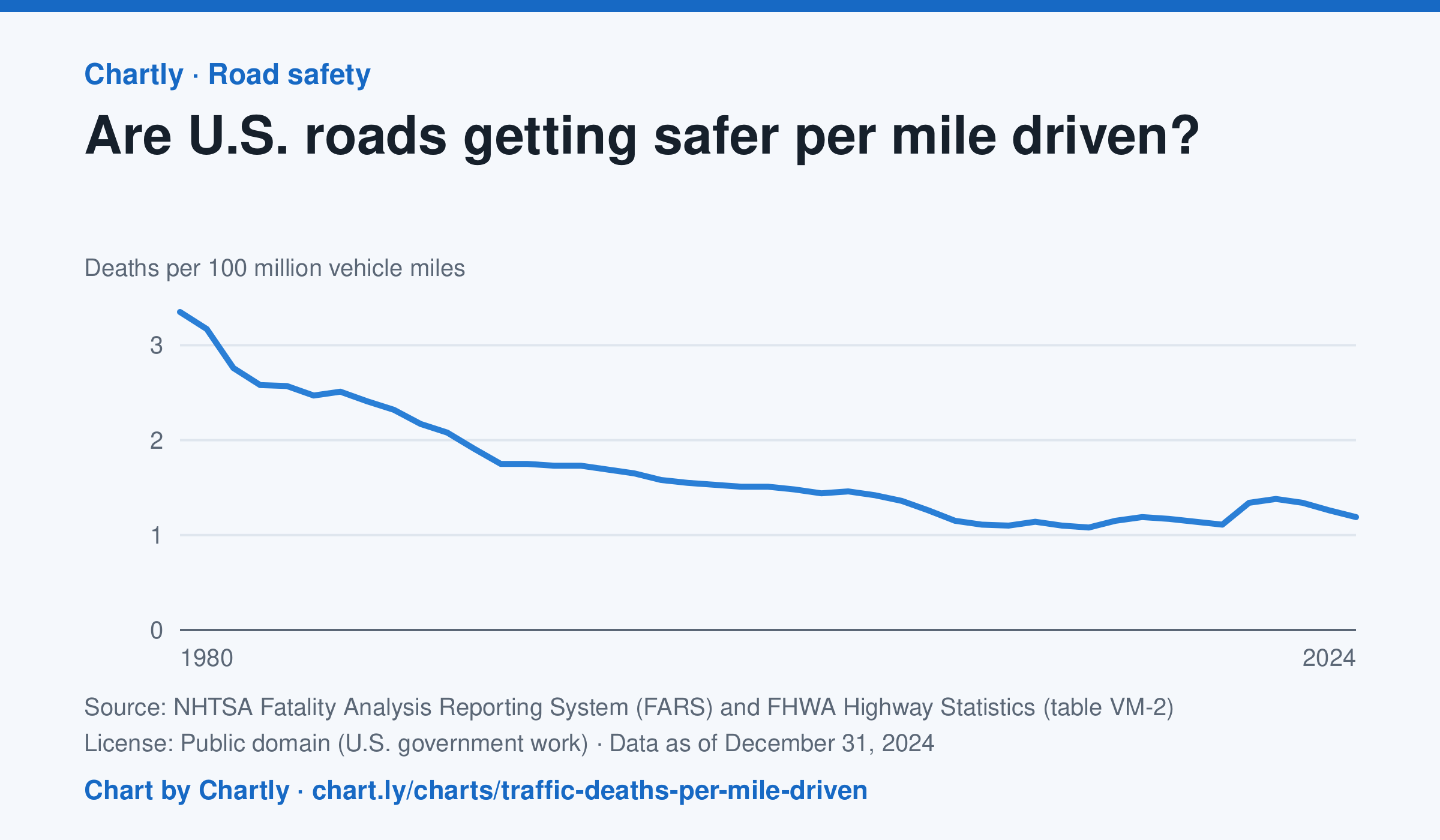
In 2024 there were 1.19 deaths for every 100 million miles driven, down from 3.35 in 1980. The lowest rate was 1.08 in 2014; it jumped to 1.34 in 2020, when people drove less but deaths rose. Miles driven are the Federal Highway Administration's estimates.
Source: NHTSA Fatality Analysis Reporting System (FARS) and FHWA Highway Statistics (table VM-2) (Public domain (U.S. government work)) · Data as of Dec 31, 2024
How to read this chart
Each point is the number of people killed in traffic crashes for every 100 million miles Americans drove that year. Dividing by miles driven turns a count into a rate, so years when people drove more or less can be compared fairly.
Questions
- About what fraction of the 1980 rate is the rate in the latest year?
- In 2020 people drove less, but the rate went up. What could explain that?
- Why is deaths per mile a fairer way to compare years than the total number of deaths?
Chart and numbers: chart.ly/charts/traffic-deaths-per-mile-driven · More free charts at chart.ly